Málaga is located in the south of the Iberian Peninsula, on the Costa del Sol (Coast of the Sun) on the northern side of the Alboran Sea (the westernmost portion of the Mediterranean Sea). It lies about 100 kilometres (62 miles) east of the Strait of Gibraltar and about 130 kilometres (81 miles) east of Tarifa (the southernmost point of continental Europe) and about 130 km (81 miles) to the north of Africa.
The Montes de Málaga mountain range (part of the Penibaetic System) is located in the northeast of the municipality. The highest point in the range (and in the municipality) is the Pico Reina, rising up to 1,031 m (3,383 ft) above sea level.[38]
The city centre is located around the mouth of the Guadalmedina and close to the Guadalhorce‘s mouth (where the airport is located). The Totalán Creek constitutes the eastern boundary of Málaga with the municipality of Rincón de la Victoria.[39]
The Gibralfaro is a 130 m (427 ft) high foothill from which the Gibralfaro Castle and the Alcazaba fortress overlook the city.[40]
Climate
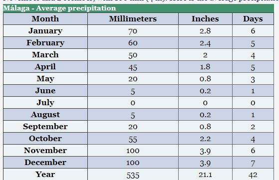
In Málaga, a city located on the coast of Andalusia, in southern Spain, the climate is Mediterranean, with mild, relatively rainy winters and hot, sunny summers.
To the north of the city, we find a mountain range, the Montes de Málaga, which reach 1,000 meters (3,300 feet) in height.
To the west of Malaga lies the mouth of the Guadalhorce River, and across the river lie the cities of Torremolinos and Benalmádena.
The wind blows frequently: in the cold half of the year, it comes along with Atlantic depressions, while in summer, it blows in the form of afternoon breeze.
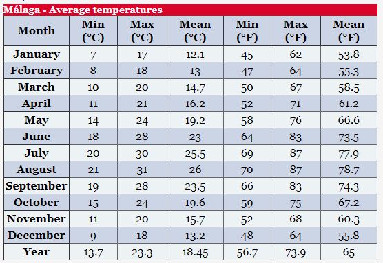
The daily average temperature ranges from 12 °C (53.5 °F) in January to 26 °C (79 °F) in August. Here are the average temperatures.
SOURCE: https://www.climatestotravel.com/climate/spain/malaga